चित्र:Ethiopia shaded relief map 1999, CIA.jpg

इस पूर्वावलोकन का आकार: ४९८ × ५९९ पिक्सेल। दूसरे रेसोल्यूशन्स: १९९ × २४० पिक्सेल | ३९९ × ४८० पिक्सेल | १,०१० × १,२१५ पिक्सेल।
मूल चित्र (१,०१० × १,२१५ चित्रतत्व, संचिका का आकार: २२२ KB, माइम प्रकार: image/jpeg)
सारांश
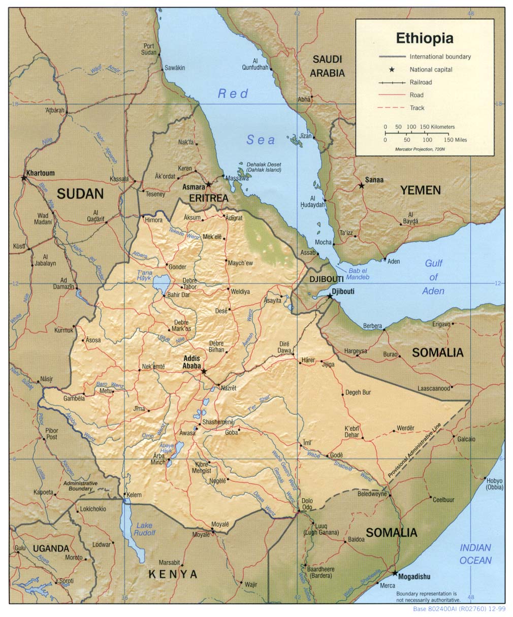
| विवरण | Shaded relief map of Ethiopia, 1999, produced by the U.S. Central Intelligence Agency. |
| दिनांक | |
| स्रोत |
University of Texas Libraries, Perry-Castañeda Library Map Collection: Ethiopia Maps |
| लेखक | CIA |
| दूसरे संस्करण |
Derivative works of this file: |
लाइसेंस
| This image is a work of a Central Intelligence Agency employee, taken or made as part of that person's official duties. As a Work of the United States Government, this image or media is in the public domain in the United States.
|

|
चित्र का इतिहास
चित्र पुराने समय में कैसी दिखती थी यह जानने के लिए दिनांक/समय पर क्लिक करें।
| दिनांक/समय | थंबनेल | आकार | सदस्य | टिप्पणी | |
|---|---|---|---|---|---|
| वर्तमान | ११:२३, २२ फ़रवरी २००६ | | १,०१० × १,२१५ (२२२ KB) | Lupo | Shaded relief map of Ethiopia. Source: [http://www.lib.utexas.edu/maps/africa/ethiopia_rel99.jpg] from the [http://www.lib.utexas.edu/maps/ethiopia.html Perry-Castañeda Library Map Collection]. {{PD-USGov-CIA}} Category:Maps of Cameroon |
चित्र का उपयोग
कोई भी ऐसा पृष्ठ नहीं है जो इस चित्र का प्रयोग कर रहा हो।
चित्र का वैश्विक उपयोग
इस चित्र का उपयोग इन दूसरे विकियों में किया जाता है:
- ar.wikipedia.org पर उपयोग
- ast.wikipedia.org पर उपयोग
- av.wikipedia.org पर उपयोग
- ba.wikipedia.org पर उपयोग
- bg.wikipedia.org पर उपयोग
- br.wikipedia.org पर उपयोग
- bs.wikipedia.org पर उपयोग
- ca.wikipedia.org पर उपयोग
- ckb.wikipedia.org पर उपयोग
- cs.wikipedia.org पर उपयोग
- da.wikipedia.org पर उपयोग
- de.wikinews.org पर उपयोग
- el.wikipedia.org पर उपयोग
- en.wikipedia.org पर उपयोग
- fa.wikipedia.org पर उपयोग
- fr.wikipedia.org पर उपयोग
- gcr.wikipedia.org पर उपयोग
- he.wikipedia.org पर उपयोग
- he.wiktionary.org पर उपयोग
- hr.wiktionary.org पर उपयोग
- id.wikipedia.org पर उपयोग
- io.wikipedia.org पर उपयोग
- it.wikipedia.org पर उपयोग
- jv.wikipedia.org पर उपयोग
- ka.wikipedia.org पर उपयोग
- ku.wikipedia.org पर उपयोग
- la.wikipedia.org पर उपयोग
- ml.wikipedia.org पर उपयोग
- mzn.wikipedia.org पर उपयोग
- nl.wikipedia.org पर उपयोग
- no.wikipedia.org पर उपयोग
- os.wikipedia.org पर उपयोग
- pl.wikipedia.org पर उपयोग
इस चित्र के वैश्विक उपयोग की अधिक जानकारी देखें।